E-Cat
Member
See: A 16 min vid documentary on the @PlanetLabs cubesat flock & launch from remote India
Also:
https://www.bloomberg.com/news/feat...tellites-ushering-in-the-new-space-revolution
Also:
https://www.bloomberg.com/news/feat...tellites-ushering-in-the-new-space-revolution
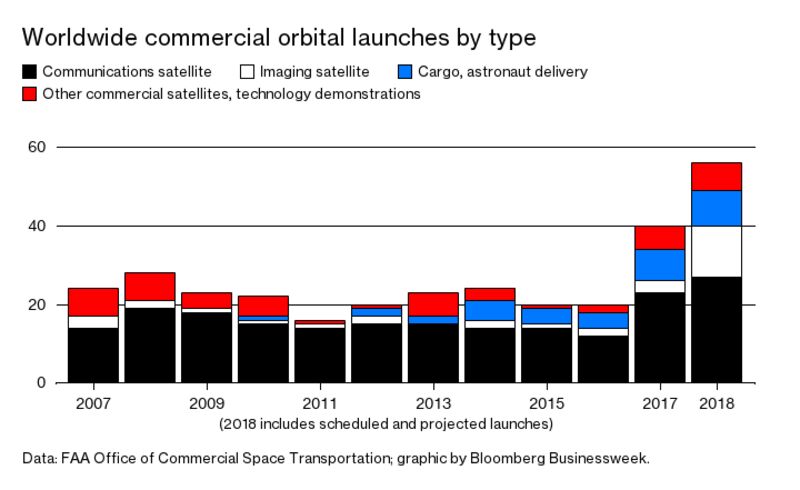
With all 149 satellites in place, Planet will be able to photograph every inch of Earths surface every daysomething even the U.S. government cant do. This satellite constellation is one of many signs that the relationship between humans and space is changing in ways unseen since Russia and the U.S. began sending rockets into orbit six decades ago. Thanks to modern software, artificial intelligence, advances in electronics and materials, and a generation of aggressive, unconventional entrepreneurs, we are awash in space startups. These companies envision an era in which rockets take off daily, filling the skies with satellites that sense Earths every actionin effect building a computational shell around our planet.
On two occasions the rockets have blown up, scattering Dove chunks across coastlines. These were expensive losses, but Planet has built such failures into its business model. If a rocket explodes, the company can simply order its employees back to the factory and start negotiating the next ride. As it is, the satellites are built to last only about three years, after which they fall back to Earth, disintegrating in the atmosphere.
When the Doves have been launched into a sun-synchronous orbit (one crossing the equator at the same local time every day), algorithms adjust their panels to guide them into position, spacing them out evenly. Getting all 88 of the Indian-launched satellites to fan out properly took a few months. As this story goes to press, theyre coming into perfect position.
Each Dove is responsible for collecting 10,000 images covering 2 million square kilometers per day, an area the size of Mexico. The pictures40 gigabytes worthare relayed during 10 daily eight-minute sessions on custom-built radios between the satellites and a dozen ground stations built by Planet in Antarctica, Chile, Hawaii, Iceland, and other places.
In the 1960s the satellite images the government needed were extremely hard to obtain. The U.S. had a program called Corona, in which an imaging satellite would take pictures and physically eject a capsule full of film toward Earth. A plane outfitted with a net would then try to catch the capsule midair. Amazingly, this system worked often enough to be useful.
The process is much simpler today, but truly high-quality images remain a rare commodity. The market leader is DigitalGlobe in Westminster, Colo., which operates a network of large satellites that produce exquisite pictures, in industry parlance. Their resolution is top-notch, capable of rendering objects as small as cars. The company says it can scan 60 percent of the Earth every month and capture specific targets on request. (The U.S. government usually gets priority.) DigitalGlobes satellites orbit at about 370 to 500 miles above Earth, higher than Planet Labs 230 to 310. In Planet Labs photos, while you can still make out cars, its hard to tell what color they are, for example.
To deal with the avalanche of new satellite imagery, companies are creating software that performs initial photo scans for movements and anomalies, then flags these for analysts. The shift toward artificial intelligence has many in the NGA feeling uneasy about their job security -- -- Gerby Marks, a counterterrorism expert and former DigitalGlobe employee, was considering retiring from the field when Planet came along. The combination of daily images and AI seemed to her a revelationa way to predict the future rather than react to the past. DigitalGlobe will only start looking at a site once there is a request to be tasked to it, she says. Now were able to detect things before we even know about them.