Aruarian Reflection
Chauffeur de la gdlk
Anyone seen this?
https://www.youtube.com/watch?v=qRv7G7WpOoU
Amazing. I'm also impressed by how quickly he can turn out a video, but I guess that comes with the territory when you do this for a living
Anyone seen this?
https://www.youtube.com/watch?v=qRv7G7WpOoU

Not looking forward to it being 40 degrees during the day this week in DC and 20 at night. The ice is going to be horrendous.
Not looking forward to it being 40 degrees during the day this week in DC and 20 at night. The ice is going to be horrendous.
Not looking forward to it being 40 degrees during the day this week in DC and 20 at night. The ice is going to be horrendous.
Not looking forward to it being 40 degrees during the day this week in DC and 20 at night. The ice is going to be horrendous.

What’s making this storm so powerful?
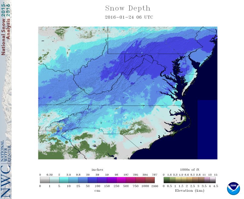
At Capital Weather Gang, Jeff Halverson has an excellent analysis of the factors leading into this remarkable storm, with the main player being a pronounced upper-level low over the Southeast that will trigger a surface low developing off the East Coast. The upper- and lower-level centers will align just east of the Delmarva in an occlusion, allowing the entire “stacked” system to slow down and prolonging the heavy snow. Also in the mix is a rich feed of moisture streaming up from the northern Caribbean, with pockets of as much as two inches of precipitable water (the amount that could be squeezed out above a given point). Temperatures are considerably warmer than average over the Northwest Atlantic, ranging from about 1°C above average near the Bahamas and northern Caribbean to 2-3°C above average off the Virginia coast northeast to the Canadian Maritimes. (Warmer-than-usual oceans are commonplace across the globe right now, as December was the warmest month in more than a century of global recordkeeping.)

Figure 3.Departures from average sea-surface temperature for this time of year, calculated for the week ending on Jan. 16, 2016. Image credit: National Hurricane Center.
Which of the factors driving Jonas is most unusual? Joe Romm (Climate Progress) and Andrew Freedman (Mashable) point out the strong, important links between rising global temperatures associated with human-produced climate change and the observed tendency for high-end precipitation events to become even heavier. Many of the record U.S. rainfall events over the past year have benefited from vast amounts of precipitable water, often at record amounts for the time of year. Winter storms rely on ample moisture as well as strong temperature contrasts and large-scale dynamics. In the case of Jonas, a crucial factor is the extreme intensity of the low-level jet stream pulling moisture from the Caribbean and slamming it around the north side of the surface low into the snow-generating machine over the mid-Atlantic. These powerful winds will replenish the atmospheric moisture being used up rapidly in the snow-making process.
I asked Richard Grumm, science and operations officer at the National Weather Service office in State College, PA, what he saw as the most noteworthy aspects of Winter Storm Jonas. He replied in terms of sigma levels, which express how often you’d expect a particular situation to recur based on previous weather patterns. A 2-sigma event (two standard deviations) occurs about 5% of the time at any given point, while a 6-sigma event is far more rare--in theory, a one-in-500-million likelihood, although the exact recurrence period for such extreme events is impossible to nail down. Grumm calculated sigma levels for the imminent storm using output from the GFS ensemble system (GEFS). Grumm noted that the precipitable water flowing into the storm is in the 1- to 2-sigma range: high but not extraordinary. However, the winds flowing from the Atlantic into the Delmarva peninsula about a mile above the surface could exceed 80 mph (see Figure 4). The east-to-west component of this wind qualifies as a 6-sigma event. Such anomalously strong winds, said Grumm, are “about as good as they get.” He added that 2012’s Hurricane Sandy was the last East Coast event to produce such a high-sigma east-to-west wind anomaly. The intensity of the upper-level front is also apparent in the very sharp south-to-north drop-off in heavy snow depicted by most models. The contrast between cold air over the Northeast and the unseasonably warm waters just offshore may help to enhance the front even further.

Figure 4. Winds at the 850-mb level (about a mile above sea level) projected by the 12Z Friday run of the GFS ensemble system (GEFS) for 7:00 am EST Saturday, Jan. 23, 2016. The lines at each point are directed into the wind; barbs along each line show the wind speed in knots (see this NWS guide). The colored areas denote estimated sigma levels (see legend at left) corresponding to the rarity of the east-west wind component. Higher sigma levels correspond to especially strong easterly or westerly wind components. Image credit: Richard Grumm, NWS.

beautiful
The front end of my car is absolutely BURIED.

beautiful
I live in Bethlehem PA they are saying something like 32 inches is the total. They originally called for like 6-10 at most. What the hell happened?
I got 24 inches in Harrisburg, PA. I'm glad I shoveled yesterday and not today like my neighbors. I'm too lazy for this shit. I made up my mind, I'm buying a snowblower at the end of the season.
I live in Bethlehem PA they are saying something like 32 inches is the total. They originally called for like 6-10 at most. What the hell happened? This is ridiculous. I had to shovel two driveways because I was dog sitting.
Unfortunately my car doesn't have remote start.Turn it on see if the heat melts it lol
