RustyNails
Member
Polar vortex unleashed: Severe cold snap likely in U.S. next week

Expected Temps next week (without windchill)

Simulation of arctic blast from Monday (12/12) to Thursday (12/15)

Departure from Normal Temps Next Wednesday (12/14)
And it's coming from Siberia


European model simulation of high-altitude weather pattern next Tuesday. The red painted line is illustrative of cross-polar flow transporting frigid air into Lower 48. A lobe of the polar vortex, having broken off from the northern part of Baffin Bay, is over south-central Canada. (WeatherBell.com)
Stay Frosty!

Expected Temps next week (without windchill)

Simulation of arctic blast from Monday (12/12) to Thursday (12/15)

Departure from Normal Temps Next Wednesday (12/14)
And it's coming from Siberia

Here's whyA punishing blast of Arctic air will plunge into the northern half of the Lower 48 in five to seven days, dispensing some of the most frigid air since 2014 or 2015 in some areas.
[The] upper-level atmosphere configuration [is] very similar in scale and magnitude as infamous January 2014 #PolarVortex, tweeted Ryan Maue, a meteorologist with WeatherBell Analytics.
Computer models are unanimous in predicting that such a cold wave will occur, although they differ some on exactly how cold and how far south and east the Arctic air will penetrate. It is unlikely that this cold wave will be as intense as the January 2014 event because it is happening earlier in the winter and less snow is on the ground in North America (snow cover acts like a freezer and helps cold air masses stay cold when they exit the Arctic).
The bitter cold air is expected to first arrive in the northern Rockies and northern Plains on Sunday. It should reach Chicago on Tuesday and the northeast United States by Wednesday or Thursday.
While subject to change, the GFS model predicts temperatures from Chicago to western Montana to be 30 to 50 degrees colder than normal next Wednesday morning.
A large area from the Great Lakes through the Dakotas and into Wyoming and Montana are predicted to have low temperatures well below zero with even colder wind chills as low as minus-30 to minus-40 degrees.
Minneapolis could have several days with highs in the single digits and lows below zero during the middle part of next week
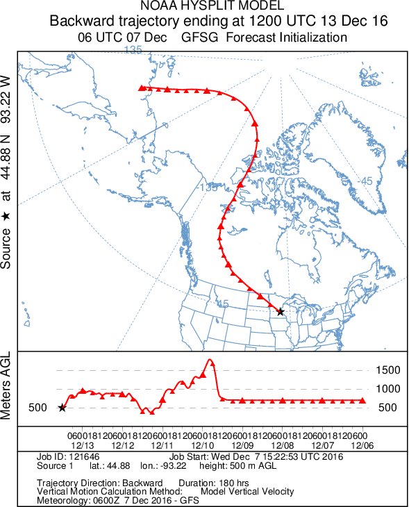
The frigid air will be sourced from Siberia, which has experienced punishing and sometimes record cold in recent weeks
Models show the cold air spilling into the Lower 48 as a lobe of the polar vortex over the northern part of the Baffin Bay (west of Greenland) breaks off and plunges south into south-central Canada. Its counter-clockwise circulation, coupled with two companion lobes of the vortex to its north, helps create what is essentially a superhighway for bitter cold air to stream across Siberia over the North Pole and into North America.

European model simulation of high-altitude weather pattern next Tuesday. The red painted line is illustrative of cross-polar flow transporting frigid air into Lower 48. A lobe of the polar vortex, having broken off from the northern part of Baffin Bay, is over south-central Canada. (WeatherBell.com)
Stay Frosty!


