
You are using an out of date browser. It may not display this or other websites correctly.
You should upgrade or use an alternative browser.
You should upgrade or use an alternative browser.
iOS 6 |OT| New Maps? googy pls
- Thread starter bananas
- Start date
How do I add stuff into Passbook? Is it through the app itself or through the App Store?
Don't really see the point in passbook, although I assume they'll add payment in there later on, and it'll be much more useful then.
They described it as confusing when you have to fumble through your apps to find the one you need. Er,not really. How many flights are you usually booked on at once. Not many. So you just bring up your airlines app, it'll probably be in a travel folder. Not really a big deal. Likewise with stores. Most apps are named after the store so they'll be easy to find. Feels like a solution looking for a problem
The_Inquisitor
Member
Don't really see the point in passbook, although I assume they'll add payment in there later on, and it'll be much more useful then.
They described it as confusing when you have to fumble through your apps to find the one you need. Er,not really. How many flights are you usually booked on at once. Not many. So you just bring up your airlines app, it'll probably be in a travel folder. Not really a big deal. Likewise with stores. Most apps are named after the store so they'll be easy to find. Feels like a solution looking for a problem
Idea is probably not having to have 10-15 apps. Consolidate into 1.
As long as it doesn't have public transportation directions I'll definitely be using the Google Maps app as well. Turn by turn driving directions are great, but doesn't really help me in NYC.
Even though I'd prefer to use the eventual google maps app for better ariel views and street view, the OS will default any web links and app links to the apple maps app. I wish you could define those. Don't suppose they are likely to have an 'open in...' for that
Why not just carry a ton of cards instead of just the Oyster card? I also think they'll be adding credit cards when NFC comes on the next phone.Don't really see the point in passbook, although I assume they'll add payment in there later on, and it'll be much more useful then.
They described it as confusing when you have to fumble through your apps to find the one you need. Er,not really. How many flights are you usually booked on at once. Not many. So you just bring up your airlines app, it'll probably be in a travel folder. Not really a big deal. Likewise with stores. Most apps are named after the store so they'll be easy to find. Feels like a solution looking for a problem
Being deeply integrated with the system's geolocation services also makes things simpler.
Newsstand had a huge effect on digital magazine/newspaper uptake on iOS, just by consolidating things into a central area and curating discovery of compatible content.
Idea is probably not having to have 10-15 apps. Consolidate into 1.
But you are still going to have those apps, they are just publishing pass info to passbook. I'll still want my airlines app to see flight information, loyalty points etc. I don't see it launching apps like newsstand. Newsstand is simpler - magazines and newspapers go in it. But passbook is for a specific piece of information - tickets, card info etc - so its not clear you'd have entire apps held within.
It's also going to be launching apps. So you'll get Newsstand with widgets.But you are still going to have those apps, they are just publishing pass info to passbook. I'll still want my airlines app to see flight information, loyalty points etc. I don't see it launching apps like newsstand. Newsstand is simpler - magazines and newspapers go in it. But passbook is for a specific piece of information - tickets, card info etc - so its not clear you'd have entire apps held within.
This Macworld article says yes.
YES!!!
Quick question for anyone running the beta.
Is there anyway to quickly send a text as an actual SMS text instead of an iMessage?
Very specific use case for this I'm sure but I wanted to check. I know in iOS 5 there was a way of holding down on the message to 'Send as Text Message', but I found it to be inconsistent.
Is there anyway to quickly send a text as an actual SMS text instead of an iMessage?
Very specific use case for this I'm sure but I wanted to check. I know in iOS 5 there was a way of holding down on the message to 'Send as Text Message', but I found it to be inconsistent.
Really annoying that the iPad 2 isn't getting Siri even though it's more than capable of running it. Classic Apple.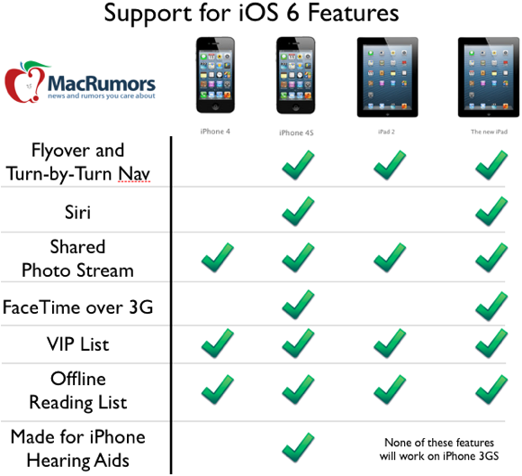
Flyover and Turn by Turn missing from iPhone 4?! Really Apple?!
Mecha_Infantry
Banned
Confirmed by Forstall.
I haven't watched the conference yet...this is all I needed. ALl those shitty upload apps are done
Thanks!
Quick question for anyone running the beta.
Is there anyway to quickly send a text as an actual SMS text instead of an iMessage?
Very specific use case for this I'm sure but I wanted to check. I know in iOS 5 there was a way of holding down on the message to 'Send as Text Message', but I found it to be inconsistent.
You have the option to hold down/send as text message if the automatic "send SMS function if an iMessage fails" feature is turned off in messages.
It's server reasons not hardware.Really annoying that the iPad 2 isn't getting Siri even though it's more than capable of running it. Classic Apple.
tycoonheart
Member
No facetime 3G for iPhone 4? What the fuck is the reasoning behind that?
What reasons are they?It's server reasons not hardware.
PwnCakes193
Member
What reasons are they?
The servers get overloaded all the time even with just the 4S officially supported. Sometimes your request will just never come through.
Even though I'd prefer to use the eventual google maps app for better ariel views and street view, the OS will default any web links and app links to the apple maps app. I wish you could define those. Don't suppose they are likely to have an 'open in...' for that
One of my biggest complaints about the OS. No true modularity. The ability to 'set as default' in android is a powerful feature that's taken for granted. On the other hand, the stronger ios becomes, the less you'll need that flexibility.
MadraptorMan
Member
To make people buy iPhone 5, duh.
Transit and walking directions: http://grist.org/news/why-the-rumors-about-the-iphone-ditching-walking-public-transit-are-wrong/
To make people buy iPhone 5, duh.
Ugh. Guess Waze is still king. Skype needs to get their shit together.
No facetime 3G for iPhone 4? What the fuck is the reasoning behind that?
Requires high-speed cellular connections. Probably for stability and picture preservation.
Really annoying that the iPad 2 isn't getting Siri even though it's more than capable of running it. Classic Apple.
Siri requires a special processor to decode speech and sound, apparently. The iPad 2 doesn't have this.
Kung Fu Jedi
Member
Transit and walking directions: http://grist.org/news/why-the-rumors-about-the-iphone-ditching-walking-public-transit-are-wrong/
That's good news for a lot of reasons. Sounds like the Maps app, while a bit bare bones at the moment, is going to flesh out into something really special down the line.
Requires high-speed cellular connections. Probably for stability and picture preservation.
Siri requires a special processor to decode speech and sound, apparently. The iPad 2 doesn't have this.
Since when does the 4S have a significant hardware boost for cellular connections?
Transit and walking directions: http://grist.org/news/why-the-rumors-about-the-iphone-ditching-walking-public-transit-are-wrong/


Kung Fu Jedi
Member
Since when does the 4S have a significant hardware boost for cellular connections?
The 4S is "4G." Just ask AT&T.
Transit and walking directions: http://grist.org/news/why-the-rumors-about-the-iphone-ditching-walking-public-transit-are-wrong/
Couldn't all this functionality already have been available if they had exposed a mapping API before?
With GMaps you can render the maps within your own application, you can set geopoints, overlays, manual route overlays and automatic routing.
Kung Fu Jedi
Member
Couldn't all this functionality already have been available if they had exposed a mapping API before?
With GMaps you can render the maps within your own application, you can set geopoints, overlays, manual route overlays and automatic routing.
This is the first release of iOS 6. How could they have made the API available before?
It's different from that. This is allowing a developer's routing app to be hooked directly into the Maps app so that it's available to the entire system. From the dev doc:Couldn't all this functionality already have been available if they had exposed a mapping API before?
With GMaps you can render the maps within your own application, you can set geopoints, overlays, manual route overlays and automatic routing.
In addition to the new map tiles provided by Apple, the Maps app and MapKit framework now support additional interactions with other apps. Apps that do not incorporate their own map support now have an easier way to launch the Maps app and display points of interest or directions. Apps that offer routing information, such as turn-by-turn navigation services, can now register as a routing app and make those services available to the entire system.
Registering as a routing app gives you more opportunities to get your app in front of users. Routing apps are not limited to just driving or walking directions. Routing apps can also include apps that provide directions for the user’s favorite bicycle or hiking trail, for air routes, and for subway or other public transportation lines. And your app does not even have to be installed on the user’s device. Maps knows about routing apps in the App Store and can provide the user with the option to purchase those apps and use them for directions.
Apps that do not provide routing directions themselves can also take advantage of both Maps and routing apps. Apps can use new interfaces to ask the Maps app to display specific locations or to display routing directions between two locations.
Transit and walking directions: http://grist.org/news/why-the-rumors-about-the-iphone-ditching-walking-public-transit-are-wrong/
Wow, that's frigging huge.
LyleLanley
Banned
Does passbook work yet? When openend up the screen does nothing for me.
Not yet, we have to wait for developers to integrate their apps with it.
Wow, that's frigging huge.
I wonder if it's going to be any better than they way Google did it. Using the public transit directions on Google Maps worked pretty flawlessly, at least for me in NYC.
Not yet, we have to wait for developers to integrate their apps with it.
Meh - thought it would use passes sent by MMS and such. Integration will be terrible in Germany.
It's different from that. This is allowing a developer's routing app to be hooked directly into the Maps app so that it's available to the entire system. From the dev doc:
Yeah yeah, I get it. Intents for iOS, finally. My point is that since previously it was Apple's application using Google map data, and whatever is mentioned there is already possible with the current maps API (apart from turn-by-turn), then they could've opened this API before, for their previous app, had they wanted to.
Deadly Cyclone
Pride of Iowa State
What's the hearing aid stuff in iOS 6? My good friend wears them and the new pair he bought bluetooth into his dumb phone now, he plans to get the iPhone 5, what can he do with iOS6?
Also, his hearing aids are ridiculous.
Also, his hearing aids are ridiculous.
Not yet, we have to wait for developers to integrate their apps with it.
I wonder if it's going to be any better than they way Google did it. Using the public transit directions on Google Maps worked pretty flawlessly, at least for me in NYC.
Google could use the routing apps API to supply the same info directly to Maps...if they wanted to, of course.

The MapKit API was there before. Many apps do use the included Maps API currently and do their own layering, geocoding, etc on top of it.Yeah yeah, I get it. Intents for iOS, finally. My point is that since previously it was Apple's application using Google map data, and whatever is mentioned there is already possible with the current maps API (apart from turn-by-turn), then they could've opened this API before, for their previous app, had they wanted to.
https://developer.apple.com/library...n.html#//apple_ref/doc/uid/TP40009497-CH1-SW1
The 4S is "4G." Just ask AT&T.
FFS, I hate that bullshit.
The MapKit API was there before. Many apps do use the included Maps API currently and do their own layering, geocoding, etc on top of it.
https://developer.apple.com/library...n.html#//apple_ref/doc/uid/TP40009497-CH1-SW1
My point is that all the functionality mentioned in that article (except turn-by-turn) could've been available in the API you linked me to if they had chosen to expose it. They had the data, they had the tiles and it was all wrapped within their own application. Now they've introduced inferior data/tiles (obviously because it's all very new) and expanded their API to try compensate for data which is no longer available because, as I can assume, was bundled with Google's data.
My point is that
Google Maps + new API >= New Maps + new API
Victory Red
Member
Are people really that bummed about lack of turn by turn for iphone 4? You'd think after ~ 2 years, you'd have picked up one of the excellent 3rd party navigation software.
So has anyone (any website) tested out turn by turn? Am really curious if I will abandon Navigon for apple's app. Apple do tend to value looks over functionality.
Yes, I tested it yesterday driving to my Aunt's, about 40 minutes away.
You start your route and lock the phone, the lock screen displays how long until your next checkpoint.

The screen will go black. When you are about a half mile from your next checkpoint the screen will light up and Siri will tell you what to expect in a half mile. At the turn she tells you to turn. When you've completed the turn she will tell you how long until your next move. Screen will go black. At any time you can obviously hit the power or home button and it will show you where you are and how long until your next checkpoint.
Everything worked great. Some map images were slow to load when I would press the home/power button but thats to be expected. Only at one point was in stopped in traffic on the highway and she thought I was just off the highway, I moved 10 feet and it picked me back up.
Also, when I had Bluetooth turned on (and it syncs with my car) I wouldn't hear anything, the screen would just light up. I wasn't on the Bluetooth Audio source on my stereo but it would be nice if she interrupted my other source (XM/CD/FM/etc.) to tell me to take a turn, just like she would interrupt if I got a phone call.
Unlocked phone view

Transit and walking directions: http://grist.org/news/why-the-rumors-about-the-iphone-ditching-walking-public-transit-are-wrong/
While potentially great in the long term, that's a problem if it no public transit options are available when it launches.
With how often I use the public transit mapping, I might hold off on updating for a couple of weeks.
V
Vilix
Unconfirmed Member
It's server reasons not hardware.
They could easily update their servers. They just want consumers to update their hardware more quickly now.
Oh, so you're saying they could have allowed other transit apps to be exposed to the system in the past? Well yeah. A lot of different things could have been done before. But we all know the situation right now with Google, so they're no longer providing Google's service as the system default for all apps anymore.My point is that all the functionality mentioned in that article (except turn-by-turn) could've been available in the API you linked me to if they had chosen to expose it. They had the data, they had the tiles and it was all wrapped within their own application. Now they've introduced inferior data/tiles (obviously because it's all very new) and expanded their API to try compensate for data which is no longer available because, as I can assume, was bundled with Google's data.
My point is that
Google Maps + new API >= New Maps + new API
The funny thing is that Google could probably make a transit app and a user could let that be the system default for transit.
Good Job Bob
Member
Oh, so you're saying they could have allowed other transit apps to be exposed to the system in the past? Well yeah. A lot of different things could have been done before. But we all know the situation right now with Google, so they're no longer providing Google's service as the system default for all apps anymore.
The funny thing is that Google could probably make a transit app and a user could let that be the system default for transit.
Yeah? How about letting us use other apps as defaults as well?
sjobs@apple.comYeah? How about letting us use other apps as defaults as well?
Sounds good to me.Transit and walking directions: http://grist.org/news/why-the-rumors-about-the-iphone-ditching-walking-public-transit-are-wrong/
V
Vilix
Unconfirmed Member
I'm pretty sure it'll go unanswered. He's..umm...dead, ya know?