-
Hey, guest user. Hope you're enjoying NeoGAF! Have you considered registering for an account? Come join us and add your take to the daily discourse.
You are using an out of date browser. It may not display this or other websites correctly.
You should upgrade or use an alternative browser.
You should upgrade or use an alternative browser.
Malaysia Airlines Flight MH370 ended in the Southern Indian Ocean
- Thread starter Oersted
- Start date
- Status
- Not open for further replies.
Holy Fucking Shit. That's got to be it.

What is your logic here? I mean i'm not claiming to know either way but why are you so sure?
toxicgonzo
Taxes?! Isn't this the line for Metallica?
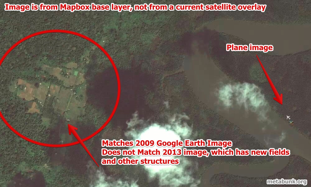
That picture has been debunked as out of date. Also, it would have been dark at the time.
https://www.metabunk.org/threads/mh370-debunked-image-of-plane-over-andaman-islands-on-mapbox-map.3304/
The NTSB sees 2 possible paths for the southern arc trip. The red area represents the new search area
https://www.metabunk.org/threads/mh370-debunked-image-of-plane-over-andaman-islands-on-mapbox-map.3304/
The NTSB sees 2 possible paths for the southern arc trip. The red area represents the new search area

AstroNut325
Member
Can we find the link to his CNN upload?
This is what I could find:
http://ireport.cnn.com/docs/DOC-1108819
tycoonheart
Member
Is mapbox a legit site?
News:
Hyderabad techie uploads satellite image of missing plane on CNN site
http://www.thehindu.com/news/cities...-missing-plane-on-cnn-site/article5801884.ece
With all this tech out here, I knew something had to come up, it be dumb to 'lose' a plane. This is interesting!
What is your logic here? I mean i'm not claiming to know either way but why are you so sure?
match the colors and has the shape of a 777
http://ireport.cnn.com/docs/DOC-1105961
And link to satellite imaging map he found it on: https://a.tiles.mapbox.com/v3/brunosan.map-cyglrrfu,brunosan.FlightMH370.html?secure=1#17/13.29431/92.99277
This is what I could find:
http://ireport.cnn.com/docs/DOC-1108819
Awesome.
And it looks like the first few comments there debunk this.
CadetMahoney
Member
IF the plane is found somewhere on land, I ask the mods to permaban my account. That's how confident I am.

So the image is old as I suspected. I couldn't find a timestamp.Awesome.
And it looks like the first few comments there debunk this.
kaiju
Member
Nevermind guys it's been debunked. Damn.
https://www.metabunk.org/threads/mh370-debunked-image-of-plane-over-andaman-islands-on-mapbox-map.3304/
https://www.metabunk.org/threads/mh370-debunked-image-of-plane-over-andaman-islands-on-mapbox-map.3304/
Plane travelled back in time.Nevermind guys it's been debunked. Damn.
https://www.metabunk.org/threads/mh370-debunked-image-of-plane-over-andaman-islands-on-mapbox-map.3304/
Plane travelled back in time.
And so did the satellite.
So the image is old as I suspected. I couldn't find a timestamp.
has time information of March 8, when you zoom out of the map and put the mouse over the green area a date show up in the corner
Can a satellite even pick up a plane in the air?if that's not the plane we're looking for, then why is it flying so low in the image?
Wouldn't the speed of the plane make the plane a blurry mess?
Already posted?
http://www.wired.com/autopia/2014/03/mh370-electrical-fire/
The simplest answer is usually the right one.
http://www.wired.com/autopia/2014/03/mh370-electrical-fire/
The simplest answer is usually the right one.
Broder Salsa
Banned
If we just all make an effort to go through all places on google street I'm pretty sure we can find it at some point.
You know, considering every theory out there gets reposted every few hours, and the number of theories increase as time goes by, it goes to follow to the logical conclusion that the rate of posts in this thread is only going to keep climbing exponentially until it tears a hole in time and space.
AstroNut325
Member
Already posted?
http://www.wired.com/autopia/2014/03/mh370-electrical-fire/
The simplest answer is usually the right one.
Pretty sure such theories have been debunked due to timing of events and satellite pings.
Slayer-33
Liverpool-2
If we just all make an effort to go through all places on google street I'm pretty sure we can find it at some point.
lol
Betta Lines
Member
The guy has since addressed the new info and his theory is still one of the most valid.Pretty sure such theories have been debunked due to timing of events and satellite pings.
There's plenty of examples of planes caught in mid air on Google Maps, blur free.Can a satellite even pick up a plane in the air?
Wouldn't the speed of the plane make the plane a blurry mess?
AstroNut325
Member
The guy has since addressed the new info and his theory is still one of the most valid.
No it does not. It claims the pilot was extinguishing flames by diving the plane? Seriously? And for some reason the author thinks disabling ACARS is like solving a chess puzzle to most pilots.
There's plenty of examples of planes caught in mid air on Google Maps, blur free.
yeah google maps does a pretty good job of catching them


obviously hard to tell what altitude they're flying at though
I don't think is any less far-fetched than any other theories. More mundane yes, but it still would have to be an extremely specific fire for it to lead to this outcome. No time to mayday, everyone incapacitated before they can put on masks, plane still OK to fly for 7 more hours, etc.Already posted?
http://www.wired.com/autopia/2014/03/mh370-electrical-fire/
The simplest answer is usually the right one.
Already posted?
http://www.wired.com/autopia/2014/03/mh370-electrical-fire/
The simplest answer is usually the right one.
I am a fan of the catastrophic incident (foul play or otherwise) + ghost plane idea, but this is just a repost of the much-discussed google+ post. BBC also had an article addressing it
Sorry guys, disappointed to find out that the news was fake ):
man this is really a mystery, it's over a week now since the plane went missing!
This really scares me, as I fly rather frequently. I'm sure many feel the same way as well.
And no closure for the affected as well. This is so depressing ):
man this is really a mystery, it's over a week now since the plane went missing!
This really scares me, as I fly rather frequently. I'm sure many feel the same way as well.
And no closure for the affected as well. This is so depressing ):
The Broken Ska Record
Member
There were similar things for 9/11. Like that one photo on top of one of the towers as a plane was getting closer.I can't believe a troll would stoop to releasing fake satellite photos for something like this. I mean that goes beyond internet troll into the realm of fucking scumbag. If it was his boss I'd probably fire him for a stunt like that.
teruterubozu
Member
I don't think is any less far-fetched than any other theories. More mundane yes, but it still would have to be an extremely specific fire for it to lead to this outcome. No time to mayday, everyone incapacitated before they can put on masks, plane still OK to fly for 7 more hours, etc.
It's the "selective fire" theory.
I can't believe a troll would stoop to releasing fake satellite photos for something like this. I mean that goes beyond internet troll into the realm of fucking scumbag. If it was his boss I'd probably fire him for a stunt like that.
i doubt it was an on purpose troll. I believe the guy may have legitimately thought he found something.
yeah google maps does a pretty good job of catching them
obviously hard to tell what altitude they're flying at though
Google aerial photography does not use satellites. All of the images you see on google and Bing, etc are all shot from a plane and at a lower altitude than commercial aircraft. The times they do catch planes its because they're landing or taking off.
Betta Lines
Member
No, his first suggestion is that the altitude readings are incorrect:No it does not. It claims the pilot was extinguishing flames by diving the plane? Seriously? And for some reason the author thinks disabling ACARS is like solving a chess puzzle to most pilots.
Reports of altitude fluctuations. Well given that this was not transponder generated data but primary radar at maybe 200 miles the azimuth readings can be affected by a lot of atmospherics and I would not have high confidence in this being totally reliable.
He then goes on to suggest that if readings were accurate, it could have been a climb to 45000ft to starve a fire of oxygen, and a stall situation happened which then recovered at 25000ft. Nowhere does he suggest diving to extinguish flames.
That was a common theory before it got known that the plane flew for hours after going silent. The satellite ping was after 7.5 hours so I doubt there was a fire. A fire would also most likely be reported by at least one system, but AFAIK the ACARS shut down before the last radio transmission indicating it was done on purpose.Already posted?
http://www.wired.com/autopia/2014/03/mh370-electrical-fire/
The simplest answer is usually the right one.
Betta Lines
Member
No, this is now unclear.AFAIK the ACARS shut down before the last radio transmission indicating it was done on purpose.
AstroNut325
Member
No, his first suggestion is that the altitude readings are incorrect:
He then goes on to suggest that if readings were accurate, it could have been a climb to 45000ft to starve a fire of oxygen, and a stall situation happened which then recovered at 25000ft. Nowhere does he suggest diving to extinguish flames.
As for the reports of altitude fluctuations, given that this was not transponder-generated data but primary radar at maybe 200 miles, the azimuth readings can be affected by a lot of atmospherics and I would not have high confidence in this being totally reliable. But lets accept for a minute that the pilot may have ascended to 45,000 feet in a last-ditch effort to quell a fire by seeking the lowest level of oxygen. That is an acceptable scenario. At 45,000 feet, it would be tough to keep this aircraft stable, as the flight envelope is very narrow and loss of control in a stall is entirely possible. The aircraft is at the top of its operational ceiling. The reported rapid rates of descent could have been generated by a stall, followed by a recovery at 25,000 feet. The pilot may even have been diving to extinguish flames.
Please read the article you are defending.
Betta Lines
Member
Oh. I missed the last line. Sorry. In any case, his first suggestion is that the altitude readings are unreliable.Please read the article you are defending.
Google aerial photography does not use satellites. All of the images you see on google and Bing, etc are all shot from a plane and at a lower altitude than commercial aircraft. The times they do catch planes its because they're landing or taking off.
I find that hard to believe considering Google bought Keyhole, which used to make software incredibly similar to Google Earth using Satellite images (before Google incorporated aerial images or launched Google Earth). I also don't think Google would have planes flying over every inch of the ocean
teruterubozu
Member
Oh. I missed the last line. Sorry. In any case, his first suggestion is that the altitude readings are unreliable.
But then that contradicts his reasoning for how the fire was put out so it won't burn up the rest of the plane.
- The ACARS transmits every 30 minutes. The last transmission was 1:07 AM.
- The final message from the co-pilot was at 1:19 AM.
- The transponder was turned off at 1:21 AM.
- At 1:37 AM the ACARS did not transmit as expected.
These are the facts we know now. It does not mean the ACARS was definitely turned off before 1:19 AM. It could have been turned off at the same time as the transponder after the final message.
I find that hard to believe considering Google bought Keyhole, which used to make software incredibly similar to Google Earth using Satellite images (before Google incorporated aerial images or launched Google Earth). I also don't think Google would have planes flying over every inch of the ocean
go look at a google map of the indian ocean....there isnt any real pictures there
Maninthemirror
Banned
NBC: plane autopilot was programmed to turn 12 minutes before "all right, good night "
Slayer-33
Liverpool-2
NBC: plane autopilot was programmed to turn 12 minutes before "all right, good night "
Welp.
I find that hard to believe considering Google bought Keyhole, which used to make software incredibly similar to Google Earth using Satellite images (before Google incorporated aerial images or launched Google Earth). I also don't think Google would have planes flying over every inch of the ocean
Figured I should have been more specific but I was on my phone and didn't feel like typing it out. Any images over land with any sort of detail are all taken by plane. If you zoom out to country/continent/world level it will be satellite imagery along with remote areas that no one cares to fly and even those are generally done by plane with a wider angle lens and much crappier resolution. Water would also be satellite imagery mixed with texture fills (the majority of it) but also taken a very long time ago. The only images they frequently update are the aerial photographs
PrimaNocta
Member
What if the plane never left the airport?

"The greatest trick the pilot ever pulled was convincing the world the plane left."
"The greatest trick the pilot ever pulled was convincing the world the plane left."
i kid i kid
- Status
- Not open for further replies.