Megalosaro
Banned
Is it possible we'll never know what happened to this plane? This is starting to sound like another Emila Earhart. The search area is literally thousands of miles
Yeah, I meant "possible" flight path.

Not a path, the flight path could be anything that gets the plane to any one of those coordinates on that line at the time if the ping.
The US Gov't and DoD has had fears of nuclear weapon use for decade. Why wouldn't they, in good conscience, be watching those bases even if it's only for a little bit? They surely would relay information like that to Malaysia since the U.S. is involved.
Is it possible we'll never know what happened to this plane?
Cheers for the amendments gents.
12:41am - MH370 leaves Kuala Lumpur for Beijing.
01:07am - ACARS shut off: likely deliberate.
01:21am - Transponder shut off: likely deliberate.
01:22am - MH370 disappears from Subang Air Traffic Control.
***01:22am+ - Timeline murky. At some point MH370 "turns back" westward across the Malay Peninsula, then turns northwest into the Straits of Malacca, and continues flying until it leaves military primary radar coverage. Aircraft movement during this period is considered deliberate.
02.40am - "Contact lost" reported to Malaysian airlines.
***06:30am - Scheduled landing in Beijing, MH370 nowhere to be found.
08:11am - Satellite "pings" MH370. Location impossible to pinpoint. Vague window of "a northern corridor stretching approximately from the border of Kazakhstan and Turkmenistan to southern Thailand, or a southern corridor stretching from Indonesia to the southern Indian Ocean"
Why would there be weapons (nuclear or otherwise) in abandoned bases?
Wasn't it being said in the beginning that the plane only had 4 hours of fuel left after the transponder was shut off?
Wasn't it being said in the beginning that the plane only had 4 hours of fuel left after the transponder was shut off? Why is it now twice the amount of time?
What exactly does cabin disintegration mean?
Wasn't it being said in the beginning that the plane only had 4 hours of fuel left after the transponder was shut off? Why is it now twice the amount of time?
Cheers for the amendments gents.
12:41am - MH370 leaves Kuala Lumpur for Beijing.
01:07am - ACARS shut off: likely deliberate.
01:21am - Transponder shut off: likely deliberate.
01:22am - MH370 disappears from Subang Air Traffic Control.
***01:22am+ - Timeline murky. At some point MH370 "turns back" westward across the Malay Peninsula, then turns northwest into the Straits of Malacca, and continues flying until it leaves military primary radar coverage. Aircraft movement during this period is considered deliberate.
02.40am - "Contact lost" reported to Malaysian airlines.
***06:30am - Scheduled landing in Beijing, MH370 nowhere to be found.
08:11am - Satellite "pings" MH370. Location impossible to pinpoint. Vague window of "a northern corridor stretching approximately from the border of Kazakhstan and Turkmenistan to southern Thailand, or a southern corridor stretching from Indonesia to the southern Indian Ocean"
Ohhhhh.....The automated message would have revealed the plane's distance from the satellite at 8.11 a.m., but not its precise location, said Mikael Robertsson, co-founder of Flightradar24, a website that uses satellite data to track commercial flights.
That was never said. What was originally reported was that the engine was subsequently sending automated pings for 4 hours (thus implying 4 hours more of flight). This was denied by Rolls Royce (confirmed) and the sites running the story then corrected it to say satellite pings for at least 4 hours after transponder was shut off (which may be related to the latest verified information, though this one goes up till 8:11AM or ~7 hours)
The airplane presumably had 8 hours of fuel, so it could have flown for 1 more hour beyond that point of last detection, at 8:11
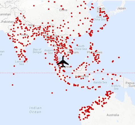
Map with most recent info

here's a really shitty (so please don't quote it) mspaint showing the distinction. Any myriad possibilities could have taken place that results in the position of the plane being along the circular red line at exactly 8:11AM. It literally could have doubled back and been at the top of the southern line, in Indonesia, for example. So saying it's a 'flight path' is misleading as that would imply it's at the endpoint furthest away.
Again why do people even assume the plane would have followed either corridor after being hijacked and having changed course more than once?

Again why do people even assume the plane would have followed either corridor after being hijacked and having changed course more than once?
Map with most recent info
No.Could the plane have flown out to space? could it be on thhe moon?
The satellite was in constant communication with one of the engines, sending flight data to engineers for monitoring. It wasn't simply picked up.Its odd that from what we are told, that no other satellites picked up the planes presence. The northern last point covers a lot of land, and no countries air radars picked it up? And to the south, Austrailia's radars didn't register the aircraft? Yet a satellite thousands of miles away in the ocean did
The satellite was in constant communication with one of the engines, sending flight data to engineers for monitoring. It wasn't simply picked up.
Could the plane have flown out to space? could it be on thhe moon?
Well, if they have the time and list of possible locations it could be at that time, couldn't they go back to the spy satellites and see if they've got photos of the plane?
I really think that this will become the "Jimmy Hoffa" of the 21st century.
I'm going to assume that the red line is actually pretty wide in real life.
The satellite doesn't even explicitly provide distance info, does it? Isn't it literally engineers going, "Ok, the ping between the satellite and engine took this long, so it's this far away..."Yeah, remember, the satellite isn't saying "this is the flight path" or "it's anywhere in this space". The satellite just provides data of how far away the aircraft is from the satellite's location. At 08:11am MH370 was pinged at X distance, and so that map shows the possible spread of locations, not necessarily how it got there. Unless the data is busted at 08:11am MH370 was somewhere along those red lines.
The satellite doesn't even explicitly provide distance info, does it? Isn't it literally engineers going, "Ok, the ping between the satellite and engine took this long, so it's this far away..."
Amazing isn't it? With all the technology that is available that when an entire jetliner vanishes there's still questions and doubt.
so let's eliminate China and India assuming they have radar capable of seeing a 777. it helps to eliminate a lot of possibles.From WNYC: 634 runways where the plane could have landed. No idea how many of them are unattended, however.
This is interesting too:
http://en.wikipedia.org/wiki/Time_of_useful_consciousness
At 45,000 feet in an unpressurized cabin, passengers and crew would only be conscious for 9-15 seconds. They'd barely have time to get out of their seats, let alone fight back.
was wondering how long it would take
that's terrifying
Not to get too much off topic but still relevant, this site.. http://www.airdisaster.com/ ..lends a very good perspective into the world of aviation mishaps and safety. There's pictures, reports, and most interestingly (sometimes eerily) audio released sometimes moments before a mishap occurs. Good info all around.
Jesus is it possible for any site to be more ad/popup-riddled
(No adblock on secondary machines go me)
Until there is confirmation of a crash anything is a possibility. However, we have no clue specifically what happened with this plane. Any article claiming to know exactly what happened is FUD.I'm reading it's a kidnapping or sorts. How reliable is this piece of news? If it is hijacked, then there's a chance the passengers are alive.
I really think that this will become the "Jimmy Hoffa" of the 21st century.
I'm reading it's a kidnapping or sorts. How reliable is this piece of news? If it is hijacked, then there's a chance the passengers are alive.
From WNYC: 634 runways where the plane could have landed. No idea how many of them are unattended, however.
I'm reading it's a kidnapping or sorts. How reliable is this piece of news? If it is hijacked, then there's a chance the passengers are alive.
Besides, those are mostly poor Chinese people who couldn't even pool a decent ransom.