-
Hey, guest user. Hope you're enjoying NeoGAF! Have you considered registering for an account? Come join us and add your take to the daily discourse.
You are using an out of date browser. It may not display this or other websites correctly.
You should upgrade or use an alternative browser.
You should upgrade or use an alternative browser.
Florida Gov. Declares State Of Emergency Over Hurricane Irma (Up: clean-up begins)
- Thread starter fluffydelusions
- Start date
SyenceLabb
Member
All of the spaghetti models are beginning to fall off the west coast. Irma is playing 4D chess.
dolabla
Member
Latest Euro ensembles:

Wow, it's coming right over me if those are the projections. I live about 70 miles from the gulf coast. We haven't had a real Hurricane since Opal back in 95.
Pattycakes
Banned
All of the spaghetti models are beginning to fall off the west coast. Irma is playing 4D chess.
I wonder if it will hit Mobile/Gulf Shores/Pensacola dead on.
Bacardi151
Member
Miles. Not feet
I'm an idiot. No idea why i wrote feet instead lol.
Friend's picture from MCO an hour ago, right before she boarded her flight:
If only it was always like that.
If only it was always like that.
No shit, right.
I love Disney World but MCO is kind of shit.
fluffydelusions
Member
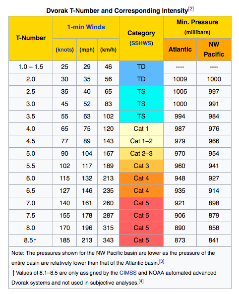
It was at T-Number 5.1 earlier today and in 3 hours got back to 5.7. Now at 5.8.

0ptimusPayne
Member
Just an update from my North Tampa Evac that we started a few hours ago. Traffic is a breeze heading north out of state, weve had zero issues as I suspected from Google Maps. Was kinda shook about not being able to find gas, but we found a couple stations south of Gainesville that had the liquid gold. It is NOT to late to get out if you want to depending on where youre at.
TyMiles2012
Member
Is there a FlightRadar24 alternative that has a weather layer for free? I'm curious on seeing how the airlines are avoiding the hurricane but the free version doesn't have a weather layer.
So it's strengthening again????It was at T-Number 5.1 earlier today and in 3 hours got back to 5.7. Now at 5.8.

RespectThySole
Member
Welp my power's out. Miramar/Pines area.
Just an update from my North Tampa Evac that we started a few hours ago. Traffic is a breeze heading north out of state, we've had zero issues as I suspected from Google Maps. Was kinda shook about not being able to find gas, but we found a couple stations south of Gainesville that had the liquid gold. It is NOT to late to get out if you want to depending on where you're at.
Certainly not too late. Earliest tropical storm force winds only expected after 8 am tomorrow, likely coming in around noon.
So it's strengthening again????
As expected, forecast to come back up to a 4
fluffydelusions
Member
So it's strengthening again????
It was expected to after Cuba.
Rodney McKay
Member
No shit, right.
I love Disney World but MCO is kind of shit.
It was fucking horrendous when I was there a month or two ago.
Was nearly late for my connecting flight there because our plane was a bit late and then at this Airport we had to RE-ENTER security because of how poorly designed it is.
Welp my power's out. Miramar/Pines area.
On and off for me.
ThatOneGuy831
Banned
Latest Euro ensembles:

Shit. I live in the Destin area. Better start making preparations if this this thing does end up making its way over here.
Carpe Carnim
Member
Update: Collier has opened another shelter at 14700 Immokalee Rd, Naples Fl. There are only 150 spaces. If you want, and can evacuate coastal areas, please consider doing so.
Iriscomeback
Member
That webcam from the south point in the keys is insane. People are still there making selfies.
Do they even have enough time left to get out of there?
Do they even have enough time left to get out of there?
fluffydelusions
Member
0ptimusPayne
Member
Yea. Just going to Supress the FUD in this thread from earlier about it being to late. With the Tolls open and a mix of people staying and people already gone there has not been any gridlock whats so ever. Its encouraging to see people help direct traffic and the gas stations and people offering to give up their cans.Certainly not too late. Earliest tropical storm force winds only expected after 8 am tomorrow, likely coming in around noon.
As expected, forecast to come back up to a 4
That webcam from the south point in the keys is insane. People are still there making selfies.
Do they even have enough time left to get out of there?
They do, but the conditions have already deteriorated further up. Marathon is receiving 50mph+ winds and is getting drenched. They'll have to drive up in those conditions.
That webcam from the south point in the keys is insane. People are still there making selfies.
Do they even have enough time left to get out of there?
Yes, but t is becoming more dangerous as time passes. 24 hours and they will see hurricane force winds.
Iriscomeback
Member
They do, but the conditions have already deteriorated further up. Marathon is receiving 50mph+ winds and is getting drenched. They'll have to drive up in those conditions.
Yes, but t is becoming more dangerous as time passes. 24 hours and they will see hurricane force winds.
Wow, I can't believe people are taking these kinds of risks for some dumb pictures.
fluffydelusions
Member
This is neat. Predicted path vs actual

E-Cat
Member
Science, motherfuckers!This is neat. Predicted path vs actual

It's amazing that we can model, compute and predict the behavior of such vast and complex systems.
GoldenEye 007
Member
This is neat. Predicted path vs actual

Yeah, the center line NHC projected paths have been pretty spot on for Irma thus far.
cpp_is_king
Member
Yes, but t is becoming more dangerous as time passes. 24 hours and they will see hurricane force winds.
Even in 50mph winds, you don't want to be driving across that bridge. I'm afraid it's already too late for them
Audioboxer
Member
Even in 50mph winds, you don't want to be driving across that bridge. I'm afraid it's already too late for them
You said it. I posted a few pictures on this page of this topic http://www.neogaf.com/forum/showthread.php?t=1430894&page=4
The camera here shows it's starting to get rougher https://youtu.be/gaErEed7UPI?list=PL9LPhV57df3yfcRFlGAqIhjCJd4zPiwpB And here you can see people are still at the furthest south part of the keys https://www.youtube.com/watch?v=X7ld45pUueQ
1700 EDT NHC Advisory:
SUMMARY OF 500 PM EDT...2100 UTC...INFORMATION
----------------------------------------------
LOCATION...23.4N 80.5W
ABOUT 50 MI...80 KM ENE OF VARADERO CUBA
ABOUT 115 MI...190 KM SE OF KEY WEST FLORIDA
MAXIMUM SUSTAINED WINDS...125 MPH...205 KM/H
PRESENT MOVEMENT...WNW OR 295 DEGREES AT 9 MPH...15 KM/H
MINIMUM CENTRAL PRESSURE...933 MB...27.55 INCHES
Even in 50mph winds, you don't want to be driving across that bridge. I'm afraid it's already too late for them
I would rather take my chances with that than attempt to ride it out in possible 10 feet of storm surge tomorrow.
cpp_is_king
Member
I would rather take my chances with that than attempt to ride it out in possible 10 feet of storm surge tomorrow.
I can't really disagree, but I think they are dead either way, honestly. I mean, I would've been gone long ago, but we aren't dealing with rational people
Wonder how far west this thing will go. Had family leave Deltona and went to Ft. Walton and now it keeps pushing closer that way. Feel bad because now they would have been better off at home it seems. Got my buffalo chicken tender, tossed in ranch, sub this evening at the Publix on 434. First time I had it on white with pepper jack cheese, goddamn delicious. They had a tower of water there btw, they've had it since yesterday to and have been limiting it to just two per customer. Store was crazy busy.
fluffydelusions
Member
wapo has article up now about that
https://www.washingtonpost.com/news...-shorelines/?tid=sm_rd&utm_term=.5ea36000a8f2
Stuggernaut
Grandma's Chippy
This is a good cam too... shows the surf really starting to pound in
https://www.youtube.com/watch?v=eNCwj35OwmI
https://www.youtube.com/watch?v=eNCwj35OwmI
Wonder how far west this thing will go. Had family leave Deltona and went to Ft. Walton amd now it keeps pushing closer that way. Feel bad because now they would have been better off at home it seems. Got my buffalo chicken tender, tossed in ranch, sub this evening at the Publix on 434. First time I had it on white with pepper jack cheese, goddamn delicious. They had a tower of water there btw, they've had it since yesterday to and have been limiting it to just two per customer. Store was crazy busy.
I LOVE the Publix sub digression in the middle of this post!
Cat in the Hat
Member
Latest IR loop

Please evacuate before its too late.

Please evacuate before its too late.
twinturbo2
butthurt Heat fan
The wind is starting to pick up a bit here. Should top out at about 80 MPH at worst with about a foot of rain at most.Finally seeing some action in Broward. Raining hard with some decent wind.
NihonTiger90
Member
1700 EDT NHC Advisory:
SUMMARY OF 500 PM EDT...2100 UTC...INFORMATION
----------------------------------------------
LOCATION...23.4N 80.5W
ABOUT 50 MI...80 KM ENE OF VARADERO CUBA
ABOUT 115 MI...190 KM SE OF KEY WEST FLORIDA
MAXIMUM SUSTAINED WINDS...125 MPH...205 KM/H
PRESENT MOVEMENT...WNW OR 295 DEGREES AT 9 MPH...15 KM/H
MINIMUM CENTRAL PRESSURE...933 MB...27.55 INCHES
Moving WNW at 295 degrees now, definitely starting to turn slowly.
Friend's picture from MCO an hour ago, right before she boarded her flight:
MCO should be officially closed down, as of 13 minutes ago.
She was probably on one of the last flights out.
fluffydelusions
Member
Science, motherfuckers!
It's amazing that we can model, compute and predict the behavior of such vast and complex systems.
And then ignore them to ride out the storm. Yeeeee haw!
MasterSheen
Member
Is there a map of flood zones for Miami Dade County somewhere?


