• Hey, guest user. Hope you're enjoying NeoGAF! Have you considered registering for an account? Come join us and add your take to the daily discourse.

Major East Coast Storm to Hit Mid-Atlantic and New England Tuesday

Status
Not open for further replies.
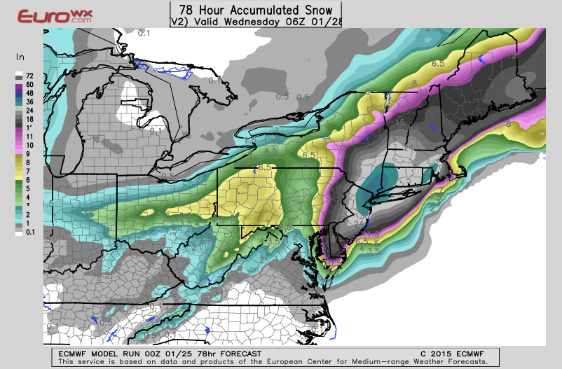
The guy puts stuff in all caps and really doesn't think about what he's doing. It's okay to be a weather fan, I'm one, but this guy should realize he's informing the public; most of whom don't understand weather models, but do understand numbers. So if they hear a very high number, even though it's projected, they'll begin to panic or worse 100% believe the projection and mistrust the forecasts next time a major storm is projected to reach the area.

Also posting that map for one forecast run is probably not a good idea. It's fine that you did, but understand that it was just one forecast run and not an official forecast.

Not sure what you're getting at. This guy is a weather enthusiast and it's his public blog. He doesn't have to pander to the lowest common denominator, some of the public (me) like to have the weather models spelled out for me better than what accuweather or cnn has to offer. He's not affiliated to any network so not sure why he would be held accountable if he's not accurate? Don't read his blog again if he's wrong then? Is that so hard?

The caps thing is the same vein as drudge report, not sure how it discredits him.

Get off your high horse.
 

Mully

Member
Not sure what you're getting at. This guy is a weather enthusiast and it's his public blog. He doesn't have to pander to the lowest common denominator, some of the public (me) like to have the weather models spelled out for me better than what accuweather or cnn has to offer. He's not affiliated to any network so not sure why he would be held accountable if he's not accurate? Don't read his blog again if he's wrong then? Is that so hard?

The caps thing is the same vein as drudge report, not sure how it discredits him.

Get off your high horse.
That comment alone. H'oh boy.

It sensationalizes weather and leads to misinformation. Sure this guy is a weather enthusiast, but to you he puts out the best forecasts. You have trust in him which is slightly scary when you consider there's people like Jeff Masters, the NWS, and qualified meteorologists that know how to put out forecasts and give out information properly.

Yes it was a beautiful model run, but unless it's verified by the 6Z GFS, the 12Z Euro and GFS, and the NAM as we get closer, no one should be putting out those numbers the way he did.

That's great you came to that conclusion off one post and then slam him for being sensationalist. Scroll through his posts you're not going to find him going off the wall. I happen to like him cause he has an ability to translate something that I have no domain knowledge in into something digestable.

But ya know, CAPS
 

Mully

Member
Blizzard Watches up for Long Island and NWS Upton has increased their accumulation forecasts to 6-14" for most of the eastern Metro area.

With that said some of the short range, high resolution(non-global) models have shifted slightly east putting most of NNJ and Westchester out of heavy snows. We'll have to see what the GFS has to say in a few minutes to see if the eastward (less snow) trend continues.
 

Mully

Member
GFS continues the global models (Euro, Canadian, and GFS) trend towards a more western, closer to coast storm(more snow) hypothesis. Below is a snapshot of the storm in the later, weakened stages of its life. It should be noted that even though it's in a weakened state the storm is still affecting the New England and the NY Metro for about 24 hours straight.

We'll have to wait 8 long hours to see if the Euro confirms.

gfs_mslp_pcpn_frzn_neus_11.png
 

OuterLimits

Member
Hmm, my wife and I are supposed to drive from Virginia to Jersey later today or early tomorrow to visit her family. I don't think it is supposed to be bad until late Monday? Mainly light snow possible before that from the clipper system?

Looking at the models is interesting. Euro nails Jersey. NAM pretty much spares most of Jersey completely, and GFS is significant but not as insane as the Euro.

Pulling for the NAM. Although I'm not sure how reliable the NAM is at 36 to 48 hours.

Last thing I want is to get dumped on by snow at my wife's family. Damn.
 

Mully

Member
Hmm, my wife and I are supposed to drive from Virginia to Jersey later today or early tomorrow to visit her family. I don't think it is supposed to be bad until late Monday? Mainly light snow possible before that from the clipper system?

Looking at the models is interesting. Euro nails Jersey. NAM pretty much spares most of Jersey completely, and GFS is significant but not as insane as the Euro.

Pulling for the NAM. Although I'm not sure how reliable the NAM is at 36 to 48 hours.

Last thing I want is to get dumped on by snow at my wife's family. Damn.

According to the latest global trends, light snow should start around 4PM in CNJ on Monday. Heavy snow begins a few hours later as the storm intensifies. Some models have the storm redeveloping with a pressure drop of more than 30MB in less than 24 hours (super intense drop even for a typhoon/hurricane).

I'd watch this closely. If the westward, stalled storm trend continues I'd have a serious talk about the trip.
 

OuterLimits

Member
According to the latest global trends, light snow should start around 4PM in CNJ on Monday. Heavy snow begins a few hours later as the storm intensifies. Some models have the storm redeveloping with a pressure drop of more than 30MB in less than 24 hours (super intense drop even for a typhoon/hurricane).

I'd watch this closely. If the westward, stalled storm trend continues I'd have a serious talk about the trip.

Yeah, not sure what to think. NWS says 6 to 16 inches in their Winter Storm Watch blurb. Quite the spread. Lol. Granted, if we got there early tomorrow, we wouldn't be heading back to Virginia until Thursday or even Friday. So a couple days of sun and the road crews should have the highways in good shape by then I would assume.
 
According to the latest global trends, light snow should start around 4PM in CNJ on Monday. Heavy snow begins a few hours later as the storm intensifies. Some models have the storm redeveloping with a pressure drop of more than 30MB in less than 24 hours (super intense drop even for a typhoon/hurricane).

I'd watch this closely. If the westward, stalled storm trend continues I'd have a serious talk about the trip.

Fuck........they better shut my store down, I work from 9pm-8am. Don't want to have to drive there and back in this shit.
 

Mully

Member
Fuck........they better shut my store down, I work from 9pm-8am. Don't want to have to drive there and back in this shit.

I'd check out Twitter, this thread, and American WX Forums for the NYC Metro around 1:30PM today.

If we still get results we've been getting I'd tell your boss it wouldn't be safe for you to come in.
 

hythloday

Member
Eastern PA Weather now calling it for heavy snow in NJ/DE/Philly area. This is just on their Facebook page - they don't have a map or anything yet. Probably waiting for later models today/tonight. We'll see if they're right. It looks like it's coming together but still too early to call for the Mid-Atlantic.

***ALERT: MAJOR NOR'EASTER WILL IMPACT EXTREME EASTERN PA, NEW JERSEY, DELAWARE MONDAY NIGHT/TUESDAY: ALARMS SOUNDED***
We remain in storm mode until further notice. Weather weeklies video will be out this morning that will concentrate on this storm, amounts, and impacts heavily. Areas outlined are below:

Action areas that need to make preparations now for one foot or more of snow, potentially two feet in eastern areas: The entire states of New Jersey and Delaware, and the following counties in eastern PA: Wayne, Pike, Carbon, Monroe, Lehigh, Northampton, Berks, Chester, Montgomery, Bucks, Delaware, Philadelphia.

Areas that need to watch this closely for major accumulations and shifts in Pennsylvania: Susquehanna, Lackawanna, Wyoming, Luzerne, Schuylkill, Lebanon, Lancaster, York. As of now, these areas need to be aware, but are not in immediate action zone.
 
So basically its gonna be snowing from Sunday night until Tuesday morning in the Philly area? 2-4 inches is suppose to fall by Monday afternoon. Looks like I'll be working from home at least one day this week
 

Culex

Banned
I live in western CT, hoping we dodge this one. I don't want a repeat of the 36 inches we got a few years ago.
 

kingocfs

Member
Just heard about this last night. Here I was thinking we would get through this winter without any blizzards. We've been pretty lucky so far. (LI)
 

DoubleD

Member
I live in western CT, hoping we dodge this one. I don't want a repeat of the 36 inches we got a few years ago.
CT GAF, yeah buddy. Preach it, bro. Although, a day off would be welcomed, being stuck at home for 3-4 days would not be.
 

S.Dedalus

Member
Oh hooray. Seacoast NH here. I would love a day to work from home, but my company's pretty shitty about snow days. Looks like this is how I die.
 

All Hail C-Webb

Hailing from the Chill-Web
But look at that one ? Seems we aint getting shit :|

That isn't a model, it's somebody's prediction for the New England area.
The models give us 1.5 - 2 inches of liquid. A typical snow to liquid ratio is 10-1. This will be a cold storm, so the ratio could go as high as 15-1.
 

Slayer-33

Liverpool-2
That isn't a model, it's somebody's prediction for the New England area.
The models give us 1.5 - 2 inches of liquid. A typical snow to liquid ratio is 10-1. This will be a cold storm, so the ratio could go as high as 15-1.

The inner evil me wants 2 feet + bring it on bro.
 
Damn! No mention of NYC. :(

... BLIZZARD WATCH IN EFFECT FROM MONDAY AFTERNOON THROUGH TUESDAY EVENING...
THE NATIONAL WEATHER SERVICE IN NEW YORK HAS ISSUED A BLIZZARD WATCH... WHICH IS IN EFFECT FROM MONDAY AFTERNOON THROUGH TUESDAY EVENING.
* LOCATIONS... THE GREATER NEW YORK CITY METROPOLITAN AREA.
* HAZARD TYPES... HEAVY SNOW AND BLOWING SNOW... WITH BLIZZARD CONDITIONS LIKELY.
* ACCUMULATIONS... SNOW ACCUMULATION OF 1 TO 2 FEET... WITH LOCALLY HIGHER AMOUNTS POSSIBLE.
* WINDS... NORTH 20 TO 30 MPH WITH GUSTS UP TO 50 MPH.
* VISIBILITIES... ONE QUARTER MILE OR LESS AT TIMES.
* TEMPERATURES... IN THE LOWER 20S.
* TIMING... HEAVIEST SNOW AND STRONGEST WINDS WILL OCCUR OVERNIGHT MONDAY INTO TUESDAY.
* IMPACTS... EXTREMELY DANGEROUS TRAVEL DUE TO HEAVY SNOWFALL AND STRONG WINDS... WITH WHITEOUT CONDITIONS LIKELY. SECONDARY AND TERTIARY ROADS MAY BECOME IMPASSABLE. STRONG WINDS MAY DOWN POWER LINES AND TREE LIMBS.
PRECAUTIONARY/PREPAREDNESS ACTIONS...
A BLIZZARD WATCH MEANS THERE IS A POTENTIAL FOR FALLING AND/OR BLOWING SNOW WITH STRONG WINDS AND EXTREMELY POOR VISIBILITIES. THIS CAN LEAD TO WHITEOUT CONDITIONS AND MAKE TRAVEL VERY DANGEROUS.
&&

More Information

... POTENTIALLY HISTORIC WINTER STORM TO IMPACT THE AREA FROM LATE MONDAY INTO TUESDAY... .

.
 

okno

Member
NYC here. I work from 4pm - 3am tomorrow. Might not be able to get home by the time I leave work, how fun!
 
If the Euro model is so much better why don't we just adopt it? Too much American pride?

Every model has their strengths and weaknesses. While the Euro has been the most consistently right, the best forecasts have come from using all sorts of different models and looking at them holistically.
 
If the Euro model is so much better why don't we just adopt it? Too much American pride?

my understanding is that it's not just a model we can just grab and use, significant equipment upgrades are necessary to get our systems up to speed with theirs.

To do that requires funding, which isn't something the current congress has any interest in.

edit: looks like this is actually happening, thanks to hurricane sandy.

http://www.wbur.org/npr/375544023/noaa-to-upgrade-its-computer-driven-weather-forecasts

SAMENOW: The European model was the first to accurately predict that Sandy, rather than hooking out to see, would actually strike the U.S. So the European model provided the most lead time for Sandy. Now, once we got within about three to five days, the American model joined the European model in providing a more or less accurate forecast.

INSKEEP: And if I'm not mistaken, the money the government wants to spend grew out of - grew out of Sandy, right? This was, like, essentially trying to deal with a lesson learned?

SAMENOW: Right. Lawmakers decided after Sandy that the National Weather Service needed more computing resources to improve its hurricane forecasts as well as its forecasts overall.

INSKEEP: So can you give us a layman's sense of what makes the difference between a pretty good computer forecasting model, which the National Weather Service seems to have now, and a much better one, which the Europeans seem to have?

SAMENOW: So I mean, basically, the European model has a lot more computing power, which means it can pick up on smaller-scale weather features. And it also means that it can better bring in data to the model, which helps improve how well the model can forecast features further out in time. Frankly, forecasters both in the private sector and within the National Weather Service tend to have more trust in the European model forecasts than they do the American forecasts.
 

Anoregon

The flight plan I just filed with the agency list me, my men, Dr. Pavel here. But only one of you!
I live about an hour north of NYC and work between here and there. If I am expected to get to work on Tuesday I will not be psyched.
 

Mully

Member
The GFS was upgraded very recently. The Euro is the most consistent model, but forecasting accurately takes more than one model. The Euro fails often at predicting northern stream storms moving south (Canada storms moving south towards Wash DC, NY). The Canadian model is horrible at making accurate hurricane predictions and storm predictions once you hit the Gulf of Mexico. The GFS has been known in previous years to have an eastern bias which means it takes longer for the model to get on board with coastal storms sometimes.

If all three major models begin to trend a certain way, meteorologists have a better shot at predicting a storm accurately than using just one model like the Euro. Sometimes the Euro is the last one to come around to events like this. Other times the Euro is the first to call days before other models.

The models are like hounds. Some are better than others in certain aspects but they all eventually get the same scent.
 

Mully

Member
The 12z GFS is in.

The storm was weaker, took longer to intensify, and was a tick east of previous model runs yesterday. We'll see if the Euro continues that trend or it remains adamant of record snow across the NY metro and New England area in just a few hours.
 
Status
Not open for further replies.
Top Bottom