You are using an out of date browser. It may not display this or other websites correctly.
You should upgrade or use an alternative browser.
You should upgrade or use an alternative browser.
Major East Coast Storm to Hit Mid-Atlantic and New England Tuesday
- Thread starter Mully
- Start date
- Status
- Not open for further replies.
aparisi2274
Member
With the recent model runs it's looking less like 2-3 feet and more like 6"-12" for NYC. What a difference a few hours make. I know people who really want a big Blizzard is waiting for the European model but if that shifts its track East I think we can safely call this a major snowstorm and not a bibical snowstorm.
I don't think it is fair to compare something as complicated and unpredictable as the weather with autonomous vehicles.
all the local news outlets are still calling for 97ft of snow....
")
Are any sites showing these new models with the less amounts?
Seven Force
Banned
4-6 inches is the threshold for my job to call off field operations I believe, so I should still be good for a day off.
Gotta say though, I was kinda hoping it would end up being as historic as it sounded. I was hoping for something as insane as the blizzards of '96, '06 or the two in 2010. (The later 2010 I had the displeasure of being stuck in, haha) Those were truly sights to behold.
Gotta say though, I was kinda hoping it would end up being as historic as it sounded. I was hoping for something as insane as the blizzards of '96, '06 or the two in 2010. (The later 2010 I had the displeasure of being stuck in, haha) Those were truly sights to behold.
all the local news outlets are still calling for 97ft of snow....
Are any sites showing these new models with the less amounts?
Check this site out. It's a forum with amateurs and pros alike.
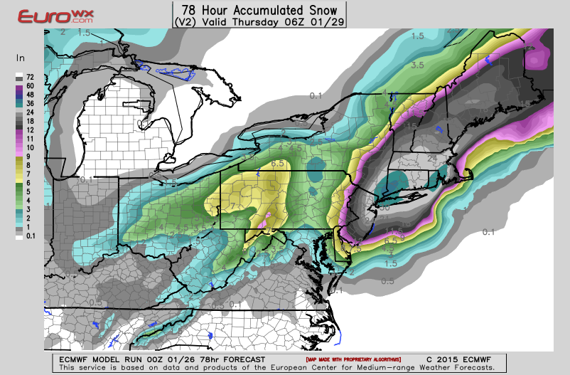
European model backed a tiny bit on the totals but still shows a 2 foot storm for the tri-state area. It shows a stronger storm, a slight tick to the east with some banding into the tri-state area.
So now we pit the most accurate weather model there is against the rest of them.
So now we pit the most accurate weather model there is against the rest of them.
Euro essentially held its ground, but ticked just a few miles more north and east of the 12z run. Accumulation totals have lessened slightly for areas N and W of NYC, but from NYC to LI to SNE get a possibly historic storm.
Here's one meteorologist's interpretation:

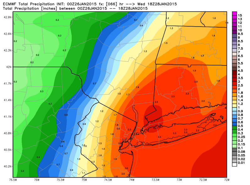
Closer look at Euro's QPF forecast for NY metro. It should be noted that ratios for these numbers are between 10:1 and 12:1 with a small chance of 15:1 in some areas if heavy banding occurs.
Here's one meteorologist's interpretation:
The ECMWF is definately east of 12z, but not nearly as far east as the rest of the guidance. It makes up for it by making the deformation band on the northwest side of the cyclone stronger (surface cyclone is stronger so more deformation along the frontogenetical band as a result). This is still a huge hit for NYC, but folks north and west of NYC will see their amounts cut.
Closer look at Euro's QPF forecast for NY metro. It should be noted that ratios for these numbers are between 10:1 and 12:1 with a small chance of 15:1 in some areas if heavy banding occurs.
GregLombardi
Member
Slayer-33
Liverpool-2
Hype inflated
With pinches of worry now....
Yep re-hyped again
TheLostBigBoss
Banned
Shouldn't have cheated Brady.... Shouldn't have cheated. Karma it seems is heading for you.
Karma is going to be a day late, they left for Arizona by the time the storm hits.
Josh with a J
Member
Awww so DC isn't getting much at all? 
Awww so DC isn't getting much at all?
DC was always on the fringe. At least you won't have a day full of shoveling ahead of you!
I need to sleep. I've gotten like two hours in the past two days because of my excitement while tracking this storm.
Josh with a J
Member
DC was always on the fringe. At least you won't have a day full of shoveling ahead of you!
But that's what little munchkin kids from the neighborhood are for!
Slayer-33
Liverpool-2
DC was always on the fringe. At least you won't have a day full of shoveling ahead of you!
lol he must feel disappointed
I'm all or nothing, gimme 30" god dammit.
Bam Bam Baklava
Member
If the response to this storm isn't right this could be Obama's Katrina.
Josh with a J
Member
lol he must feel disappointed
I'm all or nothing, gimme 30" god dammit.
I may be grown but I'm trying to tear up some hills with my sled!
Josh with a J
Member
Welp, my flight got cancelled.
Officially stranded in D.C. if they can't get me on this 8am flight.
Sup neighbor
Sup neighbor
I got on the flight. So that's good.
There's just no point in me going to sleep now as I have to leave in 2 hours.
perfectchaos007
Member
Is this going to be worse than what Buffalo got a couple months ago?
Working at a university has its benefits ....
Bring on that white stuff
What does working at a university have to do with cocaine?
If the response to this storm isn't right this could be Obama's Katrina.
That's for Kanye to decide.
maquiladora
Member
Latest

Fahrenheit
Banned
Trapped at work right now in Philadelphia. 2 inches of snow my on car so far. Really hoping my boss doesn't mandate I stay. I'm on the tail end up a very long work week.
LyleLanley
Banned
Are we still expecting it to be completely awful in NYC this afternoon?
Are we still expecting it to be completely awful in NYC this afternoon?
Possibly. NWS Upton downgraded the expected totals to 18-24," but they would still be a record breaking storm. Light snow is expected throughout the day with the heavier stuff starting as early as 4PM.

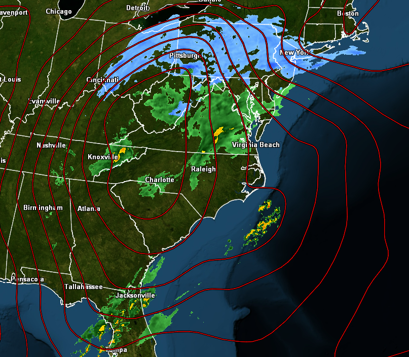
Also, the energy transfer is occurring over the coast of NC right now. Thunderstorms just began to pop up over that area over the last few hours. You're watching a new storm develop over the coast.
Fuck rip nyc.
It's going to be amusing to see if people do their usual 'shovel as its still falling down' bit.
Fahrenheit
Banned
So apparently it's on track to be historic and dangerously deadly. Shits on track to wreck some shit. (tri+state)
Following that accuweather forum thread.
Link?
Slayer-33
Liverpool-2
Trenton reporting in. Hoping we somehow get enough ice and snow to cancel classes by 12.
So far it's very mild, and just a coating. It's not supposed to really get going until tonight, is it?
I work in Trenton (live I. Mt laurel), my kids have school closings at noon today and should be off tomorrow, enjoy your snow day on Tuesday.
teruterubozu
Member
It looks like the brunt of the storm will be up in Boston instead of New York now.

Josh with a J
Member
Starting to half snow / half rain here
woo woo
woo woo
Stormwatch
Member
My parents are in White Plains, NY. They are so screwed...
- Status
- Not open for further replies.